|
OLD PLYMOUTH
. UK |
||
|
© Brian
Moseley, Plymouth Webpage created: August 21, 2018 Webpage updated: April 19, 2020 |
||
|
|
||
|
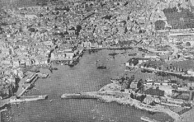
- SUTTON HARBOUR (SUTTON POOL) Sutton Pool, or Sutton Harbour as it is now known, is the birthplace of the modern City of Plymouth. The first Anglo Saxon settlers sailed in to this inlet and made their first settlement on its shore. Here they built their fishing boats and mended their nets. From here the Town grew, northwards and westwards at first, thanks to the money earned in the port through trade, and it was from here that the Pilgrim fathers sailed in 1620.
Sutton Harbour, Plymouth, from the air. When the Anglo Saxon invaders came to the southern coast of Devon around the year 700AD they came by sea because the travel by land was difficult and dangerous. They landed along the coast and settled there, close by the coastal churches of Revelstoke, Newton Ferrers, and Wembury. Sailing in to Plymouth Sound they would have been confronted by the steep limestone cliffs of the Hoe. They would have sought lower, sheltered places to settle and thus found the two inlets later known as Sutton Pool and Stonehouse Creek. Near the latter they founded Stoke, with its parish church, and near the inlet to the east they founded Sutton Meaning the "south farm" in Anglo Saxon, it is thought to have been on the north shore of the Pool, possibly near the junction of North Quay with Sutton Wharf. This would have been at the southern end of North Street, thought to have been an ancient routeway northwards to Tavistock. Its line above Camden Street has been lost under development.
An early picture of Sutton
Harbour with the spire of the Sutton Pool was larger then, with an arm running where The Parade now stands up to the bottom of Buckwell Street. There may have been another inlet at the bottom of Looe Street and it is said that there was a creek that ran behind Cattedown between Sutton Pool and the Laira. Suggestions were apparently made in 1814 for turning this into a canal. The most likely location for the first habitation was near the junction of two streams at Bilbury Bridge. The two streams are mentioned by Worth and ran from Shute Park near the Free School and from Hampton Shute. Bilbury Street was called Bilbury Bridge and must have crossed the former stream which flowed into a long-filled creek of the Pool. King Henry I (reigned 1100-1135) gave the manor of Sutton, along with Maker and King's Tamerton, to Reginald de Valletort of Trematon Castle near Saltash on the River Tamar as a reward for his faithful service. He moved to the shores of Sutton Pool and built a new residence somewhere adjacent to the modern front of Saint Andrew's Church. This is the "Old Town" towards which the later Old Town Street led, possibly when North Street ceased to be the main road out of the area. It was the Valletorts who granted the land of Sutton Prior to the Prior of Plympton, leaving the Old Town to be in the Manor of Sutton Valletort or Vautort. Saint Andrew's Church was built in the 12th century. St Andrew Street, alongside the Church, certainly existed by 1386. Sutton must have been a place of reasonable local importance because in 1254 King Henry III (1216-1272) granted a market in the town to the Prior of Plympton. It was also at this time that the 'port of Plimmue' was mentioned in documents. The port belonged to the King in 1284, through the Earl of Cornwall, the King's brother, at Trematon Castle. When the last Earl died in 1310 the estates reverted to the Crown. At this time an inquiry revealed that the King held six acres of land recovered from the sea, thought to be the area around The Parade. This established the principle that land recovered from the sea is Crown property. In the 1300s the Prior of Plympton established his rights to the quays on the south side, which eventually passed to the Corporation while the Crown still held the waters of the Pool. The Earl of Cornwall title was given to Piers Gaveston who held the Pool because it was the waters of the Tamar in the Manor of Trematon. When he died it passed to King Edward II's queen, Isabella. Edward the Black Prince, his son, was made the first Prince of Wales and Duke of Cornwall and from that day on the monarch's eldest son has always held the Duchy of Cornwall estate. In 1617 the Pool was leased by the Duke of Cornwall, Prince Charles (later to become King Charles I), to John Sparke and John Fowell of Plymouth for 21 years at a yearly rent of £13 6s 8d. In the meantime the Corporation of Plymouth had purchased the Manor of Sutton Prior and in 1637 bought the Manor of Sutton Valletort from the Hawkins family. As a result, they claimed the land between low water and high water belonged to them. An agreement was reached in 1757 as to which land was owned by the Corporation and which by the Duchy. At the time of the Civil War (1643) the eastern side of the Pool was outside the Town Wall, which only existed as far as Martyn's Gate, near a quay belonging to Mr Sparke. Sutton Pool was regarded as a defence in itself. In modern terms, Martyn's Gate was outside the present Bretonside Bus Station, adjacent to the Martyn's Gate School building. The two piers at the entrance to the Pool were constructed in 1791 and 1799. This made the harbour safer from the tides but resulted in it silting up due to the lack of the scouring action of the sea. The Pool was apparently drying out at every spring tide. The surviving lessee of the Pool at this time was Mr Thomas Lane, previously a partner of Mr Humphrey Hall of Manadon House but in 1810 it was taken over by Mr John Hawker at a cost of £13,000. On June 26th 1811 the royal assent was given to the Sutton Pool Act and in 1812 the Prince Regent gave a 99-year lease to the new company formed under the Act -- the Sutton Pool Company. This had local businessmen as shareholders and so for the first time they had control over their harbour and had the power to raise £50,000 to improve the quays. In November 1844 adverts appeared for the Sutton Harbour and Dock Company, from which the property of the Sutton Pool Company would be transferred. The aims were to turn it into a floating dock and link it to the South Devon Railway. Neither were achieved: the Admiralty forbade the conversion into a floating dock and the railway went past the Pool towards the newer Millbay Docks. The railway finally arrived at Sutton Pool in 1852 by which time the mails had been transferred to Millbay. The next major event was the formation by Act of Parliament in 1847 of the Sutton Harbour Improvement Company. A subsequent Act in 1876, when the London & South Western Railway arrived at the Pool, gave them the right to purchase the Harbour from the Duchy of Cornwall for £38,000. This took a long time to achieve and the actual completion was not made until March 31st 1891. They purchased, according to Crispin Gill: ~all the water, soil and pool of Sutton situate near the Borough of Plymouth ~ along with the ancient rights to levy charges on ships entering the harbour, every piece of cargo loaded or unloaded and a charge on the fishing boats coming in plus dues laid down for the use of the quays.
From a postcard. Incidentally, the Pool is a creek within the limits of a Royal Dockyard, as defined in an Act of 1865, and therefore comes within the jurisdiction of the Queen's Harbourmaster. It was proposed in the 1870s to convert 13 acres of the Pool into a floating dock but the Sutton Harbour Improvement Company failed to raise the necessary capital of £160,000 and the scheme was abandoned. Details of the work that was done at this time is given below, under North East Quay. Since 1989 the Pool has been owned by Sutton Harbour Holdings PLC and many improvements have been made, especially noteworthy being the lock gates at the entrance and the new Fish Market, opened in 1995 at a cost of £3 million. It was designed by the Architects Design Group of Plymouth and erected by MacAlpine's. The lock gates were designed by engineers L G Mouchel and the lock was constructed by Messrs Christiani & Neilson. Work started on January 1st 1992 and the lock was finally sunk into place on April 23rd 1993. For information about the goods imported in to Sutton Harbour and the Cattewater SEE Port of Plymouth Imports. THE QUAYS AND WHARVES IN A CLOCKWISE DIRECTION FROM WEST PIER Old Fish Market Quay -- The Act enabling the Fish Market to be erected was obtained in 1889. Whitehouse Pier Quay Road Guy's Quay Little Vauxhall Quay, built in the 1830s. Vauxhall Quay -- its predecessor, the Dung Quay, was created in 1639 at the bottom of Looe Street and the Tin Quay at the bottom of How Street. Sutton Jetty -- Built circa 1893. Goods shed. Sutton Wharf, built 1813-15 by the Sutton Pool Company. In 1972 some seventy moorings for yachts were laid off the Wharf and within a very short time all the spaces were taken. By 1974 there were 200 moorings and even more on a waiting list. North Quay Built 1849-50. Joseph Locke was the engineer. The storehouse of the Plymouth and South Devon Co-operative Society was on this Quay.
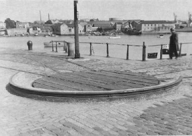
The now vanished turnplate
at Sutton Harbour, North East Quay. Work started in January 1879. First a trench was dug out in to which was put an 8 feet layer of concrete to carry the front wall of the quay. The wall itself had a concrete backing, dressed with limestone facings and granite copings. The masonry was dovetailed into the concrete to give additional strength. At this point an old archway gave access for horses to a mud bank, where they were washed. The archway was continued under the Quay and the mud and rock removed to low water level of ordinary spring tides to deepen the harbour. This was thus the end of the old horse-wash. The creek which at this point ran towards Jubilee Street was also filled in. The cost of this work was expected to be between £10,000 and £12,000. The engineers were Messrs Galbraith and Church of Victoria Street, Westminster, and the contractor was Mr T Lang, of Liskeard, who was represented at the works by his son, Mr J C Lang. Following this work a line of mixed gauge railway was laid from the terminus of the London and South Western Railway Company's Sutton Harbour Branch right around North Quay and Sutton Wharf to a goods shed on Sutton Jetty. Space would not permit the line to be curved so turn-plates were installed at the corners of the quays. Marrowbone Slip Shepherd's Wharf
Sutton Pool,
Plymouth, looking towards Shepherd's Wharf. Unnamed quay Johnson's Quay, c1825 -- The Johnson brothers owned the granite quarries on Dartmoor and operated the Plymouth and Dartmoor Railway to bring the stone down to the harbour for transhipment. Lockyer's Quay 1833 -- Edmund Lockyer was a director of the Plymouth & Dartmoor Railway Company and was involved in many other local ventures. He became Mayor. Quay dates from 1833.
The old entrance to Sutton Harbour, with the
Bayly's Wharf -- Mr Robert Bayly (1839-1901) was the chairman of the Sutton Harbour Improvement Company from 1891 to 1901. The Wharf was opened on May 12th 1900 when the steamer "Newark" landed 1,500 tons of coal at the Gas Company's yard. All the work was done by hand and only seven or eight trucks could be loaded in a day. In June 1907 the Plymouth Steamship and Coal Company completed the installation of a new electrically-operated discharging plant and ferro-concrete coal silos at Bayly's Wharf. They were the first in the country. It enabled 40 or 50 trucks to be loaded in a day. A 45-ton crane with a 45 feet jib conveyed the coal from the ships' holds to the silos. The crane ran along an iron gantry 120 feet long and 90 feet in height, this being supported by five massive iron standards. Suspended from the crane was a large "grabber", which was lowered in to the hold and lifted between two and three tons of coal at a time. The crane then ran along the side of the silos and the coal was emptied in to the hoppers, passing through two screens that divided the coal in to three qualities - house coal, nuts, and slack. The silo was divided in to four sections, each capable of holding 1,000 tons of coal. There were sixteen automatic screens for loading railway trucks and another eight for loading carts used in the domestic coal trade. A 20 horse-power electric capstan was used to haul the trucks in and out of the building and along the quay. It could haul twenty fully loaded trucks at one time. The crane was driven by a 40 horse-power motor. It also had a slewing motor of 10 hp and a traversing motor of 15 hp. The Plymouth Steamship and Coal Company employed five steamers to carry coal to Plymouth from collieries in Northumberland and Yorkshire. Phoenix Wharf Pier is outside the limits of Sutton Harbour.
|
||